I am busy planning by excursions for July and in the process decided that I need to beef up on my equipment for when I venture into dangerous areas.  I will write more on my equipment and the stuff that I am buying later, but I want to first share something else that I realized.

In my planning of the new routes I realized that I am actually creating my own adventures.  Some of the routes that I lay out can be easily converted into an official MTB route, but some of them are simply too wild and somewhat dangerous to simply be a recreational MTB route.  It contains some serious climbing, some really mean single track and in some cases extensive tracking while pushing or carrying your bike.  It not only requires physical strength and stamina, but mental strength and stamina as well.  I therefore realized that I am actually not laying out new routes, but I am actually planning adventures.  (It was then that I realized that what I am doing is just a personalized version of adventure racing.  I am not very knowledgeable about adventure racing, but I am now starting to wonder whether I may perhaps find myself within this sport. )

Lisa de Speville posted an excellent article on the topic of Micro Adventures on the ar.co.za website.  In it she develops a case for planning your own adventures and building weekend and holiday breakaways into micro adventures.  In these you cross a mountain along a new route, you cycle, hike and run in the same trip or you plan your own (sometimes difficult on purpose) routes to get to a destination.  You go off the beaten track.  You take the difficult route simply because it is there and you would like to see how it looks.  You build your own adventure.  Using this approach, no holiday or training run ever needs to be boring.  It may mean that some more intense planning is recovered, that we need more gear and that we may venture to the edge of true danger, but the rewards are truly spectacular.  You test yourself physically and you grow mentally.  It is not just mountain biking.  It is custom mountain biking and a kind of mountain biking obstacle course.

Below is a photo taken by Gary Perkin during the 2009 ABSA Cape Epic.  These guys, being small on their bikes, were enjoying themselves and had the ride of their lives, but without knowing it, they had big shadows.  The Venda people say that you have a heavy shadow when you have authority and that your life and your words have an impact  on other people.  If adventures build us and develop our characters, it is perhaps a good idea to create our own adventures to grow in character and develop a big shadow.
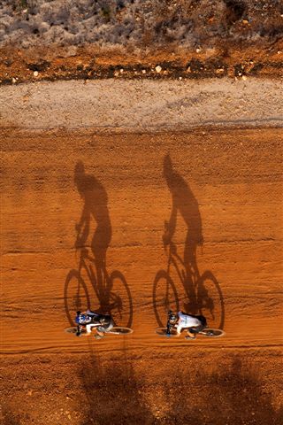
Twin bike shadows - Gary Perkin

I recently decided that I will rather say that I am planning an MTB adventure that to say that I am designing MTB routes. The route that I travel may become a more official route, but when I plan it, I simply plan it to be an adventure. So when I started to plan my MTB adventures I realized that I need some tools to guide me on the way. Here are the tools that I used.

Smartphone and mount
I originally had a HTC Desire  smartphone that is exactly the same size as the iPhone. Its specs of importance are
• Touch screen
• GPS and assisted-GPS
• 3G and HSDPA data connection
• Android 2+ operating system
I since upgraded to the HTC One X  that essentially have the same specs, but is bigger in size.
I use the Topeak Phone Drybag  to mount my phone on my handlebar. It keeps the phone dry and still allows interaction with the touch screen. The HTC Desire fits perfectly into the bag, but the HTC One X does not fit.
Software
The reason for listing the specs of the phone is that I want to use it as a cycle computer and GPS. Depending on my application I usually use one of two software packages. Remember that I am using Android, but both these packages are available for the iPhone as well.
Endomondo  is a very good cycling computer and GPS logger. Its main disadvantage is that it needs an active data connection during a training run to upload the data to the Endomondo website. When in Gauteng this is not usually a problem, but when out in the mountains of the Western Cape this is a problem. The need for a data connection also drains the battery faster. Its advantages are that it provides voice readouts of your progress every kilometer. I find this very helpful. It also provides realtime updates of your position (remember the data connection) on the Endomondo website, so my wife can track exactly where I am. I provides all the required GPS things such as speed, distance and altitude logging. It is a good software package for when you are not too far from the city or big town. It is essentially a GPS add-on to your phone. Endomondo does not have too much extra features. It is easy to use and does what it is supposed to do.
The other software package can be considered as the big brother of Endomondo. ViewRanger  market themselves as the “App for adventure” and this is exactly what it is. It changes your smartphone into a full-fledged off-road GPS system absolutely free of cost. You can download high accuracy topographical maps onto your device so that you do not need a data connection to get the map info while on the trail. It also has the ability to give you waypoint guidance based on a route stored in memory (more on the creation of a route later on). With this feature you can create a route before the time and go and explore that unknown section of mountain without having to memorize the map before the time or being afraid of getting lost. It is loaded with features and somewhat tricky to get to know, but it is really worth the effort. I have used it with great success in the wild mountains. As mentioned before, you do not need a data connection, so your battery life is extended. Apart from being a truly awesome adventure GPS it also tracks your route while guiding you and does all the things that you would expect a cycling GPS to do.
How I use the tools
From the start I decided that I wanted to used Google Earth to track down all those interesting trails. Since I focused on the area of De Rust in the Western Cape, I started with hints from the locals and from my own knowledge of places that I wanted to explore. I was surprised that jeep-track is clearly visible and that you can even see single-track in some cases.
I used the Path Tool (Click on a folder in Google Earth, then right-click and Add->Path) to create a track on top of the intended route. By looking at the properties of this track you can determine the overall distance and the elevation profile.  Look at a previous post of mine to see the tracks and elevation profile created in this way.

To get the route on my GPS (ViewRanger), I exported the path as a .kml file. Then I converted the .kml file to a .gpx file using an online converter. I then go you the my.Viewranger.com website where I log into my profile, load the .gpx file and save it as a route. By synchronizing my phone to the website the route is downloaded to my phone and I can follow it.
It is not necessary to have, but I find it quite helpful to have the topographic maps available while I am being guided by the GPS. I therefore download the topographic maps of the whole are that I intent to scout to my phone while at phone. Once downloaded I tell ViewRanger that I want it to work in offline mode and it uses these maps during my navigation.

But, be warned: The old saying of a rugby match is not played on paper, but on grass holds true for cycling as well. You can get the route and the elevation profile, but what does a 30% incline really mean? Is that faint route still accessable? Does the road snaking across the river and down the kloof even exist any more? Google Earth does not tell you where fences and gates are. It does not show you who the owner of a piece of the track is and it does not tell you where you can expect sand, rocks and extreme gravel. I have found that I usually doubled my time when riding a route that I planned in this way for the first time. But, having said that, I must say that it is awesome to plan my adventures in this way.
1:50 000 Topographic Maps

I recently also came across a free set of 1:50 000 topographic maps of South Africa which can be downloaded from the Spatialreference website. These can be used to give you more insight into the area that you are travelling through by adding information that Google Earth does not contain.
Happy exploration!

Oude Muragie Valley

Posted: March 31, 2013 in Uncategorized
Tags: , ,

From some of my other posts you will notice that I promote the town on De Rust in the Western Cape as a premier destination in mountain biking.  This post presents one of the most accessible and also one of the most scenic routes around De Rust.

Route Setting

The Oude Muragie (meaning Old Ruin) valley is a narrow valley on the Oudtshoorn side of De Rust.  A gravel road that forms a direct link between De Rust and the Cango Caves runs down this valley.  It houses a number farms with the focus being on olives, seed onions, lucern, Angora goats and sheep.  The combination of the characteristic Klein Karoo vegetation with the lucern fields, the olive orchards and the poplar woods lining the river that runs down the valley forms a truely picturesque setting.  I suggest that you time your visit to the valley with the time that the sun rises into it as this could result in some really inspiring photographs.

The Route

After a relatively easy climb from town to the turnoff from the N12 main road, the route starts to follow a high quality gravel road with a gradual climb towards the back of the valley.  Depending of where you turn around and head back to town, the route consists of about 250 m rise in elevation over the 15 km towards the back of the valley.  The climb up Spitskop Pass at the back of the valley is quite a stiff one.  I therefore exclude it from this route discussion and will rather include it in the more involved route discussions.

Time, Water and Weather

  • One can expect to complete the 30 km of the route in about 1.5 hours of easy riding and around 2 hours when a lot of photography stops are made.
  • With this route time one should be able to carry enough water, but if problems arise feel free to knock on any door in the valley to ask for assistance.  The water in the river will also be suitable for human consumption.
  • Expect some extremely hot conditions with temperatures in the mid 40’s in the summer, to take care and rather cycle early morning in the summer.  You can expect some chilly pockets of air in the winter, but there is no reason for avoiding the route then.  Put on some good gloves and the classic arm and leg warmers and you should be OK.  The fact that this area get winder rain actually increases to the awe of the route.

Google Earth

Unfortunately WordPress does not allow the inclusion of the Google Earth KML files.  I have therefore simply changed the extension of the KML file to .DOC and privided it in the following link: Oude Muragie – kml.  Simply download the file, rename the file with the .KML file extension and open it in Google Earth.

The two images below first show where the route is in relation to the towns of Oudtshoorn, Prince Albert and De Rust and then show where the route is location realtive to De Rust with the third image showing the route’s elevation profile against distance.

Wide angle Google Earth view of the route including Oudtshoorn, PRince Albert and De Rust

Wide angle Google Earth view of the route including Oudtshoorn, PRince Albert and De Rust

Close-up view of the route and the town of De Rust.

Close-up view of the route and the town of De Rust.

Elevation profile

Elevation profile

Software

I usually use one of two software packages for my route logging and guidance.  Endomondo is good for route logging and for realtime feedback on your progress.  When I only go on a local ride where I want to monitor my progress I will use Endomondo.  My wife can check my whereabouts on the Endomondo website and the software give audible voice feedback on my progress.  The disadvantage with Endomondo is that it requires an active internet connection.

For my travels in the wild mountains of the Klein Karoo I prefer to use Viewranger which can be used to give you route guidance link a normal GPS will do in the city.  I will provide a more indepth review of the software soon.

If you download Viewranger onto your phone and mount your phone onto your bike, you can use the software to guide you on the route.  The route is defined as the Oude Muragie Valley.  You can simply download the route to your phone and follow it.

Happy cycling.

June planning

Posted: April 23, 2012 in Uncategorized
Tags: , , ,

I have been silent for a very long time, but upon local request I have decided to start up die blog and to document the local routes around De Rust.  I will try to do it as comprehensively as possible.  I will include the ones that I have done and that I have discovered and that I am planning to do.  If anyone is following this blog and already have some trials or want to make some suggestions, please do so.

We will be there again during June/July this year (2012).  I plan to log all the routes using Endomondo running on my HTC Desire phone.  I will describe the tools that I use in detail at some stage.

De Rust Dam Rail Trail

Posted: July 7, 2010 in Uncategorized

I want to call the first trail that I am reviewing the De Rust Dam Rail Trail (all puns intended). The Google Earth image of the trail is presented below.  I will write at a later stage about the equipment that I am using to log the track.  The name of the trail is derived from the fact that it is located close to De Rust, the Stompdrift Dam and that it runs next to the railway line for quite a while.  The .kml file that can be loaded into Google Earth is included below the image. Note that, due to some kind of security constraint on WordPress, I could not load the file as a .kml file that can be loaded into Google Earth.  So I renamed it (right click on the file after you have downloaded it) to a .doc file.  You simply need to rename it to a .kml file before you open it in Google Earth.

First proper logging of the De Rust Dam Rail Trail

W20100707082759

Please note that this is a log of my travels and that some part of the trail crosses private land.  Please consult with Anton Schoeman at Die Gat Guesthouse regarding the access of private land before you plan to do the trail.

The full review of the trail will follow…

MTB in De Rust

Posted: July 5, 2010 in Uncategorized

We are currently visiting my in-laws at De Rust (35 km from Oudtshoorn – 33°29’21.04″S , 22°32’5.81″E) in the Western Cape.  We are fortunate to be able to come here every winter for a period of 4 weeks while I do research and the children recover from the impact that the city air have on their health.  I try to do as much cycling as I can, but this year I was not fit enough when we came here 3 weeks ago.  Well, we are almost ready to leave again and now I am fit enough to actually put in 40 or 50 km, so I will see what I can do in the couple of days that remain.

Yesterday I did a very nice route (I will review it later today or tomorrow) around the Stompdrif Dam.  While cycling, I realized that De Rust has the potential to become an MTB destination in its own right.  We visited Willowmore on Friday to see what Willowmore looks like (there is little to see…) and while we were there I discussed the impact of the Transbaviaans MTB race (http://www.gardenroute.org/trans/) on the town of Willowmore with my wife.  Doing a couple of quick calculations we thought that the race could easily add about R500 000 to R1 000 000 of outside money to the economy of Willowmore.  (Anyone with more accurate figures are welcome to correct me – these are simply my estimates.)  So, while cycling, I suddenly realized that De Rust has the possibilites to generate the same type of income from the influx of MTB enthusiasts.  I am not talking about huge stage races, but the mere mortal MTB enthusiast who wants to cycle and see the scenery while doing this.  The people I am talking about are guys (and girls…) for whom camping or simple back-packing type of accomodations would be adequate to act as a home-base for their MTB excursions.  The main impact on the area will be to bring people from the outside into the area.  They will bring their money, but they will be granted the opportunity to see a very beautiful area from the comfort of their seatpost…  All it will take is someone to get excited and take up the challenge… I will collaborate with any local person who wants to take these ideas further.

I will to try to list the trails that I found in the area and also to propose new trails.  I think Google Earth is a very valuable tool and I will make use of it whenever I cannot visit the area myself.

My MTB excursions

Posted: July 5, 2010 in Uncategorized

The idea of this blog has been going for some time, but it really came into being yesterday, so I decided to do it immediately.  I stay in South Africa and I am a keen mountainbiker, but I am mortal – meaning that I am not in shape to do the Cape Epic of other multi-stage races which are meant for the MTB deities… .  When I get to a new place, I want to go on an MTB excursion, but it is usually no good asking the locals, because they don’t see anything in their area.  For them nothing is new and beautiful anymore.  So, this blog will act as a way to present some of the places that I have visited and the unlisted tracks that I have found.  I will not try to say that I am this great rider or that the places are really awesome.  It is simply a log of what I have done, and if it is of any use to anyone else, it will be great.  So, happy reading and please comment and suggest as I start to add new stuff.